Field Notes
<--2023-03-23 10:00:00 | 2023-04-11 08:30:00-->Other sites visited today: Mayberry | West Pond | East End | Bouldin Corn | Bouldin Alfalfa | Hill Slough
Phenocam link: Searching...
Gilbert Tract: 2023-04-03 09:50:00 (DOY 93)
Author: Daphne Szutu
Others: Carlos
Summary: Regular data collection/cleaning, some new reeds coming up
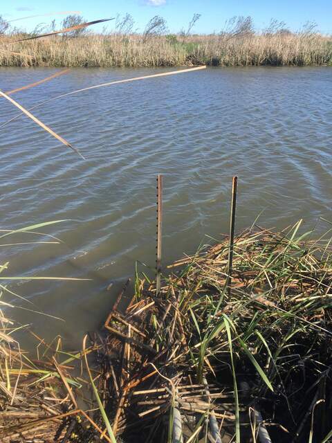
| 2023-04-03 Gilbert Tract Carlos and I arrived at 9:50 PDT. It was clear and cool with a cold wind. After yet another atmospheric river last week, I think there will finally be a pause in major rain events (or maybe it will never rain again). It was near low tide, although it was the higher of the two daily low tides. The staff gauge read 52cm at 8:53 PST. The new boardwalk into the wetland is great! Some green vegetation is starting to come up, especially along the edges. I downloaded met, cam, and USB GHG. Carlos cleaned flux and rad sensors and topped off the wash reservoir. He happened to be cleaning the 7700 at 9:00 PST when the auto spray/spin started. Carlos and I checked the 7700 fuse and one of its screws, which were both dry. The urban tower 7700 on the Berkeley Way West building had a lot of water damage from this winter’s storms, so today we are checking all of the Delta 7700s. Since the fuse, fuse cap, and one of the 7700 screws was dry, we decided the 7700 interior is probably dry. The 7500 read: 429ppm CO2, 275mmol/m3 H2O, 10.0C, 102.1kPa, 103SS --> 103 after cleaning The 7700 read: 2.0ppm CH4, 58RSSI –> 84 after cleaning We got to the channel around 10:30 PDT to download data from Flo. Carlos downloaded the data, reset the clock to match the laptop time, and restarted logging. I put on waders and got in the water to attempt to rake up some submerged aquatic vegetation. The water level was also too high to get into a good position to reach below the ADCP. I think I got one plant that was growing upslope of the ADCP. The water has been quite turbid so I couldn’t see if there was any vegetation in front of the ADCP. We left around 10:40 PDT. |
1 photos found

20230403GT_TurbidChannel.jpg ( 2023-04-03 10:21:59 ) Full size: 1440x1920
Turbid water in the channel, probably from all of the storms. Makes it hard to see if there's any submerged aquatic vegetation.
8 sets found
Can't check MBWPEESWGT_mixed
Can't check MBEEWPSWEPGT_cam
16 GT_met graphs found
4 GT_flux graphs found
3 GT_adcp graphs found
1 GT_cam graphs found
2 GT_usgs graphs found
No data found for GT_chanexo.

