Field Notes
<--2023-09-28 12:25:00 | 2023-10-26 14:10:00-->Other sites visited today: Gilbert Tract | Mayberry | West Pond | East End | Bouldin Corn | Hill Slough
Phenocam link: Searching...
Bouldin Alfalfa: 2023-10-11 16:15:00 (DOY 284)
Author: Daphne Szutu
Others: Kyle, Mel
Summary: Regular data collection/cleaning, discing alfalfa field by levee road
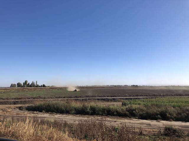
| 2023-10-11 Bouldin Alfalfa Kyle, Mel, and I arrived at 16:15 PDT. Mel is a new grad student in Iryna’s lab interested in mammal/bird benefits from wetland restoration projects. It was breezy, sunny, and mild. Our alfalfa is about calf height and looking reasonably dense. Two farmers were working in the alfalfa two fields to our east, the field right up against the levee road. One farmer was discing and the other farmer was rolling/smoothing. I called Ben to see if we needed to move our tower. He said he still works for “the district,” but directed me to call Jose who works directly with the farmer. I’m assuming “the district” is the LA Metro Water District, or maybe the reclamation district? Jose said they’re just plowing that one alfalfa field since it was underperforming and they’ll plant wheat next. Our alfalfa field is still doing fine so they’re not planning on plowing it any time soon. Kyle took spectral measurements and Mel took veg height measurements. I downloaded met, cam, USB GHG, FD, and IRT data. Mel cleaned flux and rad sensors. The 7500 read: 402ppm CO2, 430mmol/m3 H2O, 22.3C, 100.9kPa, 95SS--99 after cleaning We left at 16:35 PDT. |
Next Mowing: 2023-10-17
Veg Height (cm): Tape measure from ground to top of plant
45, 52, 38, 41, 43, 33, 41, 39, 43, 35, avg = 41, stdev = 5.35
1 photos found

20231011BA_Discing.jpg ( 2023-10-11 16:08:24 ) Full size: 1920x1440
Alfalfa field closest to the levee is getting disced. The farmers plan to plant wheat.
7 sets found
4 BA_flux graphs found
21 BA_met graphs found
6 BA_arable graphs found
Can't check TATWBABCSB_cam
Can't check MBSWEEWPBCBA
2 BA_processed graphs found
No data found for BA_adex.

