Field Notes
<--2019-01-22 10:00:00 | 2019-02-20 09:30:00-->Other sites visited today: Tonzi
Phenocam link: Searching...
Vaira: 2019-02-07 12:30:00 (DOY 38)
Author: Joe Verfaillie
Others: Dennis, Kuno, Robert, Baptiste, George
Summary: Showing the site to Kuno, Robert, Baptiste, George, Very wet, tree down at the pond.
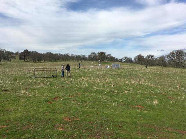
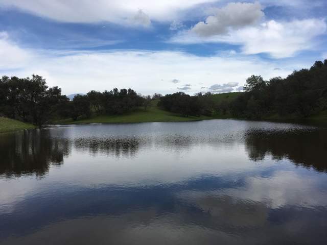
| Vaira 2019-02-07 I arrived at about 12:30 with Dennis, Kuno and Robert. We were joined by Baptiste Dafflon from LBL and George Moussally from Mirage Systems. Baptiste and George were there in association with the SMAP project and are thinking that Mirage System may fly a Ground Penetrating Radar over the site to try to get at soil moisture. The ground is very wet and the water hole is full. I collected the data. Dennis did the soil moisture but missed the gate probe. We tried to use the Jaz to take some spectra but the sky was partly cloudy and the incoming light was changing pretty fast. I measured the well. The well level was 54.2ft. We drove most of the way to the pond but got stopped on the uphill section because it was too wet without 4-wheel drive. We walked the rest of the way to the pond. There was an oak down across the near side of the dam. The pond was full and spilling over. The pond level was 22.28ft. |
Veg Height (cm): Tape measure from ground to top of plant
2, 5, 4, 4, 2, 4, 2, 3, 2, 6, 4, 2, 5, 4, 5, 9, 2, 2, 6, 6, avg = 4, stdev = 1.9
Field Data
No tank data
Well Depth
| Date | Location | Depth (feet) |
|---|---|---|
| 2019-02-07 | TZ_floor | 26.9 |
| 2019-02-07 | TZ_tower | 31 |
| 2019-02-07 | TZ_road | 34.45 |
| 2019-02-07 | VR_pond | 22.28 |
| 2019-02-07 | VR_well | 54.2 |
mode = both
Moisture Point Probes TZ
Array
(
[0] => Tower_1
[1] => Floor_South_1
[2] => Floor_West_1
[3] => Soil_Transect_4_1
[4] => Soil_Transect_3_1
[5] => Soil_Transect_2_1
[6] => Soil_Transect_1_1
[7] => SoilCO2_West_A_1
[8] => SoilCO2_West_B_1
[9] => SoilCO2_West_C_1
[10] => Tower_2
[11] => Floor_South_2
[12] => Floor_West_2
[13] => Soil_Transect_4_2
[14] => Soil_Transect_3_2
[15] => Soil_Transect_2_2
[16] => Soil_Transect_1_2
[17] => SoilCO2_West_A_2
[18] => SoilCO2_West_B_2
[19] => SoilCO2_West_C_2
[20] => Tower_3
[21] => Floor_South_3
[22] => Floor_West_3
[23] => Soil_Transect_4_3
[24] => Soil_Transect_3_3
[25] => Soil_Transect_2_3
[26] => Soil_Transect_1_3
[27] => SoilCO2_West_A_3
[28] => SoilCO2_West_B_3
[29] => SoilCO2_West_C_3
[30] => Tower_4
[31] => Floor_South_4
[32] => Floor_West_4
[33] => Soil_Transect_4_4
[34] => Soil_Transect_3_4
[35] => Soil_Transect_2_4
[36] => Soil_Transect_1_4
[37] => SoilCO2_West_A_4
[38] => SoilCO2_West_B_4
[39] => SoilCO2_West_C_4
)
| Date | DOY | Rep | Depth | Tower_1 |
Floor_South_1 |
Floor_West_1 |
Soil_Transect_4_1 |
Soil_Transect_3_1 |
Soil_Transect_2_1 |
Soil_Transect_1_1 |
SoilCO2_West_A_1 |
SoilCO2_West_B_1 |
SoilCO2_West_C_1 |
Tower_2 |
Floor_South_2 |
Floor_West_2 |
Soil_Transect_4_2 |
Soil_Transect_3_2 |
Soil_Transect_2_2 |
Soil_Transect_1_2 |
SoilCO2_West_A_2 |
SoilCO2_West_B_2 |
SoilCO2_West_C_2 |
Tower_3 |
Floor_South_3 |
Floor_West_3 |
Soil_Transect_4_3 |
Soil_Transect_3_3 |
Soil_Transect_2_3 |
Soil_Transect_1_3 |
SoilCO2_West_A_3 |
SoilCO2_West_B_3 |
SoilCO2_West_C_3 |
Tower_4 |
Floor_South_4 |
Floor_West_4 |
Soil_Transect_4_4 |
Soil_Transect_3_4 |
Soil_Transect_2_4 |
Soil_Transect_1_4 |
SoilCO2_West_A_4 |
SoilCO2_West_B_4 |
SoilCO2_West_C_4 |
Avg | Spacial Count |
Measurement Count |
|---|---|---|---|---|---|---|---|---|---|---|---|---|---|---|---|---|---|---|---|---|---|---|---|---|---|---|---|---|---|---|---|---|---|---|---|---|---|---|---|---|---|---|---|---|---|---|
| 2019-02-07 | 38 | 0 | nan | 42 | 31.7 | 38.4 | 22.6 | 31.4 | 29.7 | 28.8 | 39 | 32.3 | 27.6 | 40.8 | 39.3 | 37.4 | 40.5 | 33.4 | 35 | 40.8 | 34.2 | 43.6 | 35 | 37.4 | 46.3 | 42.1 | 39.9 | 35.2 | 36.3 | 37.4 | 36.6 | 35.7 | 40.5 | 41.7 | 50.6 | 45.4 | 35.4 | 46 | 47.7 | 41.1 | 45.4 | 50.9 | 47.7 | |||
| 2019-02-07 | 38 | 1 | nan | 42 | 31.7 | 39 | 28.8 | 31.4 | 29.7 | 28.2 | 37.3 | 34.1 | 29.4 | 41.4 | 39.3 | 38.1 | 40.6 | 34.1 | 36.3 | 40.8 | 33.6 | 44.2 | 35.6 | 36.8 | 45.2 | 40.5 | 40.5 | 35.2 | 36.7 | 3841.1 | 46 | 35.2 | 40.5 | 42 | 50.6 | 45.7 | 35.4 | 46.3 | 47.1 | 46 | 50.6 | 47.7 | ||||
| 2019-02-07 | 38 | 2 | nan | 41.4 | 31.7 | 38.4 | 29.1 | 26.4 | 29.9 | 28.5 | 39 | 34.1 | 29.7 | 41.7 | 39.3 | 37.4 | 41.1 | 34.4 | 35 | 40.2 | 34.1 | 39.9 | 35.6 | 36 | 45.2 | 41.3 | 40.7 | 34.5 | 36.3 | 37.4 | 36.6 | 36 | 39.5 | 40.5 | 49.1 | 45.1 | 34.8 | 44.3 | 47.7 | 40.5 | 45.4 | 50.3 | 48 | |||
| 2019-02-07 | 38 | Avg | 0-15cm | 0 | 0 | |||||||||||||||||||||||||||||||||||||||||
| 2019-02-07 | 38 | Avg | 15-30cm | 0 | 0 | |||||||||||||||||||||||||||||||||||||||||
| 2019-02-07 | 38 | Avg | 30-45cm | 0 | 0 | |||||||||||||||||||||||||||||||||||||||||
| 2019-02-07 | 38 | Avg | 45-60cm | 0 | 0 |
mode = both
Moisture Point Probes VR
Array
(
[0] => Solar_Panels_1
[1] => Flux_Tower_1
[2] => Biomass_Cage_1
[3] => Solar_Panels_2
[4] => Flux_Tower_2
[5] => Biomass_Cage_2
[6] => Solar_Panels_3
[7] => Flux_Tower_3
[8] => Biomass_Cage_3
[9] => Solar_Panels_4
[10] => Flux_Tower_4
[11] => Biomass_Cage_4
)
| Date | DOY | Rep | Depth | Solar_Panels_1 |
Flux_Tower_1 |
Biomass_Cage_1 |
Solar_Panels_2 |
Flux_Tower_2 |
Biomass_Cage_2 |
Solar_Panels_3 |
Flux_Tower_3 |
Biomass_Cage_3 |
Solar_Panels_4 |
Flux_Tower_4 |
Biomass_Cage_4 |
Avg | Spacial Count |
Measurement Count |
|---|---|---|---|---|---|---|---|---|---|---|---|---|---|---|---|---|---|---|
| 2019-02-07 | 38 | 0 | nan | 30.8 | 22.6 | 23.2 | 28.9 | 31.3 | 23.4 | 31.8 | 19.3 | 42.1 | 42.4 | 30.5 | 33.4 | |||
| 2019-02-07 | 38 | 1 | nan | 31.4 | 21.7 | 22.4 | 28.3 | 31.6 | 2432.1 | 31.8 | 19.5 | 33.7 | 42.8 | 30.5 | ||||
| 2019-02-07 | 38 | 2 | nan | 30.5 | 21.2 | 22.6 | 28.3 | 31 | 23.4 | 31.5 | 20.1 | 31.5 | 42.5 | 30.8 | 33.1 | |||
| 2019-02-07 | 38 | Avg | 0-15cm | 0 | 0 | |||||||||||||
| 2019-02-07 | 38 | Avg | 15-30cm | 0 | 0 | |||||||||||||
| 2019-02-07 | 38 | Avg | 30-45cm | 0 | 0 | |||||||||||||
| 2019-02-07 | 38 | Avg | 45-60cm | 0 | 0 |
No TZ grass heigth found
No VR grass heigth found
No VR Tree DBH found
No water potential data found
No VR Grass Biomass data found
No VR OakLeaves Biomass data found
No VR PineNeedles Biomass data found
2 photos found

20190207VR_Site.jpg ( 2019-02-07 13:17:03 ) Full size: 1920x1441
Dennis, Baptiste, Kuno, Robert on site.

20190207VR_PondClouds.jpg ( 2019-02-07 13:33:49 ) Full size: 1920x1440
The pond is full with more rain coming.
9 sets found
16 VR_met graphs found
2 VR_flux graphs found
6 VR_soilco2 graphs found
2 VR_pond graphs found
Can't check TZVR_mixed
No data found for VR_fd.
No data found for VR_processed.
No data found for VR_arable.
No data found for VR_soilvue.

